| South Downs - United Kingdom |
| Complete description
of case study |
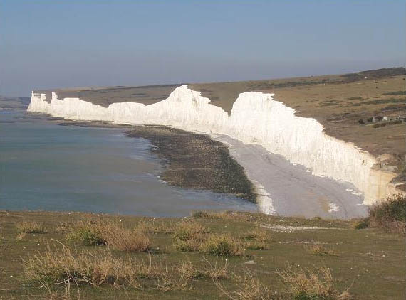
PHOTO OF THE SITE
 |
|
CASE STUDY
| Title | South Downs |
| National level | United Kingdom |
| Regional level | East Sussex |
ABSTRACT
|
The South Downs area of the Sussex coast is taken into account together because this area forms one coastal cell. Although erosion has always taken place on the Sussex coastline, human intervention has recently increased erosion along the Sussex cliffs. Defending the soft cliffs against erosion causes a sediment deficit further downdrift and the construction of piers and groins causes an interruption of longshore transport, leading to leeside erosion. Furthermore, because sea walls and groins have largely fixed the coastline, the coast has lost its resilience. Due to the relatively rapid erosion rates, most of the towns along the Sussex coast are at risk. Sea defences in front of the towns minimize the damage to property. However, along the taller cliffs damage cannot always be prevented. The major functions along the South Downs coastline are agriculture, tourism and recreation, light industry, nature conservation and residential development. Until now the policy option has been to hold the line in places where significant infrastructure or housing concentrations are present. A changing policy has been adopted over the last few years: the coast should be left to natural changes as much as possible, for aesthetic and technical reasons (protection decreases sediment supply areas further downstream). The community’s interest is put above individual interests. This viewpoint, of course, leads to many conflicts, but the policy of holding the line will only be applied if large concentrations of people or big investments are threatened. |
BASIC INFORMATION
| Coastal characteristics |
|
| Policy options | Historical:
hold the line Present: managed realignment |
| Socio-economic activities | Agriculture, tourism and recreation, light industry, nature conservation and residential development. |
| Engineering techniques | Seawall, groins, shingle nourishment. |
SOURCE
| Name | Paul
Sistermans Odelinde Nieuwenhuis |
| Institution | DHV group |
| Address | Laan
1914 nr.35, 3818 EX Amersfoort PO Box 219 3800 AE Amersfoort – The Netherlands |
| Telephone / fax | +31 (0)33 468 37 00 / +31 (0)33 468 37 48 |
| paul.sistermans@dhv.nl odelinde.nieuwenhuis@dhv.nl |