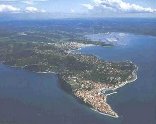
| Slovenian coast - Slovenia |
| Complete description
of case study |
PHOTO OF THE SITE
 |
|
CASE STUDY
| Title | Slovenian coast |
| National level | Slovenia |
| Regional level | Slovenian coast |
| Local level | Municipality of Piran and Municipality of Izola |
ABSTRACT
|
Slovenian coast is a shallow marine basin, with maximum depths in its central part 20-25 m and average depth of 17 m, situated at the junction of the Dinaric Alps and the Alps. Sea erosion of rock coastline through the waves and tide, is of low intensity due to small driving forces. It is comparable to erosion due to weathering on slopes inland. Shifting of coasline inlands due to sea erosion is pronounced only in uninhabitated areas and nature reserves, while the majority of inhabitated coastline is erosion protected by artificial structures. However, during extremely high tide events the stretches of low coast are flooded for some hours short periods several times a year. These parts of the coast are protected by various artificial structures ranging from seawalls and rip rap breakwaters to rock dikes. Cliffs in inhabited areas are protected by wire mesh, in exceptional cases also by concrete sills, stone walls and concrete walls. Areas of the coastal plains are protected by seawalls and submerged rip rap breakwaters. Tourism development in Piran, and other parts of the coast, sprawls outside the city creating needs for new infrastructure, is excessive beyond the carrying capacity of the coast and the road network. The urbanisation of the coastal strip together with the increasing employment opportunities led to intensive migration of inhabitants from hinterland to the coast. The major changes in the narrow coastal strip in the last decades (abandoning of salt production in Luclja, the construction of tourist facilities including yachtmarinas, the development of the port of Koper, infrastructure) resulted in a serious loss of natural coastline and degradation of the coastal ecosystems. There is less than 20 % of natural coastline left. Salt extraction used to be one of the important economic activities in the area. The most important policy option that was chosen and adopted is “hold the line”, which is implemented in most parts of the coastal zone, that are urbanised or occupied by intensive uses. Only the parts of the coast, that are either nature reserves or uninhabitaded areas are subject to natural processes, and are left to natural dynamics, with the soft policy option of “limited intervention”. In the area of the Port of Koper, the policy option is to “move seawardIn general, the approach to solving erosion problems of the coastline is local, using proper technical solutions and appropriate land use. Only the problem of filling up the Gulf of Trieste with sediment transported by rivers, is delt with regionally and internationally, trying to retain the sediments inland. |
BASIC INFORMATION
| Coastal characteristics |
|
| Policy options | Hold the line, limited intervention, move seaward |
| Socio-economic activities | Nature conservation, tourism |
| Engineering techniques | Seawall, submerged breakwater, dyke |
SOURCE
| Name | Marta Vahtar |
| Institution | Institute for Integral Development and Environment |
| Address | Savska 5, 1230 Domzale (Slovenia) |
| Telephone / fax | +38 61 722 5210 / +38 61 722 5215 |