| Vagueira-Mira - Portugal |
| Complete description
of case study |
PHOTO OF THE SITE
 |
|
CASE STUDY
| Title | Vagueira-Mira |
| National level | Portugal |
| Regional level | Aveiro district |
| Local level | From Douro Estuary to Cape Mondego (Costa Nova) |
ABSTRACT
|
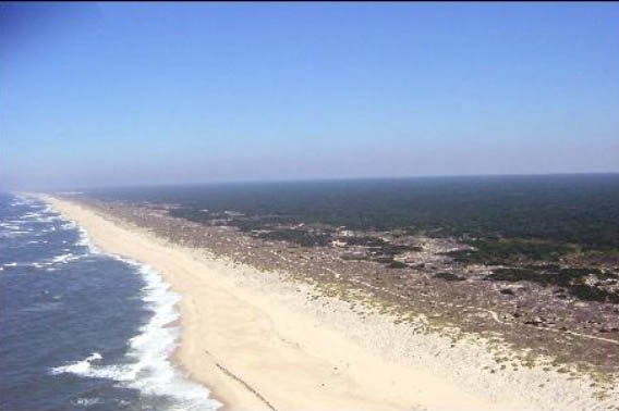
This area is located in the Centre region of Portugal, in the Aveiro district, south of the inlet of Aveiro lagoon, distinguished by the dune system along the whole extension, starting in Costa Nova village and ending in Mira beach. The length of the study area is 15km, with a NNE-SSW coast orientation and could be characterized by a long beach with extensive flat areas, where there isn’t much accentuates reliefs. The adopted policy in the coastal management plan Ovar – Marinha Grande, approved in year 2000, was to hold the line and managed realignment. The first policy is for urban areas and the second is for areas not urbanized above all downdrift of the groins to establish a new line of equilibrium. One of the main measures that coastal management plan foresee is the dune system reconstruction between Costa Nova – Vagueira beach and Vagueira beach – Mira beach. This artificial dune is “parallel” to the coastal line foreseen in situation of static equilibrium. This is justified by “the expectation that the dune cordon will keep breaking an in alternative to its reconstruction after each rupture episode, mad0e the option could be the construction of an artificial cordon in a retreated position where it is waited that the evolutionary process stabilizes”. |
BASIC INFORMATION
| Coastal characteristics |
|
| Policy options | Managed realignment, Hold the line |
| Socio-economic activities | Tourism, Agriculture, Fishery, Harbours |
| Engineering techniques | Groyne, jetty, nourishment |
SOURCE
| Name | Fernando
Veloso Gomes Francisco Taveira Pinto |
| Institution | Hydraulic and Water Resources Institute - IHRH |
| Address | Rua
Dr. Roberto Frias, s/n 4200-465 Porto |
| Telephone / fax | +351 22 508 1907 / +351 22 508 1952 |
| vgomes@fe.up.pt fpinto@fe.up.pt |