| Haute-Normandie - France |
| Complete description
of case study |
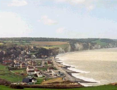
PHOTO OF THE SITE
 |
|
CASE STUDY
| Title | Haute-Normandie |
| National level | France |
| Regional level | Conseil Régional de Haute-Normandie et Conseil Général de la Seine Maritime |
| Local level | Pays de Caux |
ABSTRACT
|
The cliffs of the study area extend over 130 km of shoreline. The cliffs have an average height of 70 m. A wide shore platform (150-300 m) develops at their feet, covered on its landward margin by a thin shingle or pebble beach. These cliffs are cut by numerous dry and drained valleys perpendicular to the shoreline, and protected by a shingle beach. The evolution of the cliff coast is influenced by the combination of marine and continental processes. The pebble beaches are under the impact of the action of the hydrodynamic conditions, especially the wave. It is very hightly exposed to the western storms. Because of the shapes of the Channel sea-floor and the coasts, this area is subject to macrotidal tides creating alternative currents parallel to the coastline. These currents carried only mud and coarse grained. The dominant direction is to the NE. The transport of the pebbles is dominated by a longshore drift. The direction of the dominant longshore is SW-NE. This is strongly influenced by man’s actions (pears, jetties, extraction) modifying the volume and the progression of the protective pebble beaches. Tourism and recreation are the major functions of the coastal zone. The coastal erosion management in Haute-Normandy and Picardy has been performed through construction of rigid defences in times of crisis which have a limited lifetime, a localised effect, and are often disruptive for the pebble longshore drift. An increase of the rockfall frequency appears at the immediate down of transversal sea defences (harbour jetties or major groynes), showing the impact of these obstacles on the pebble longshore drift. The adopted policy option is do nothing for the cliff erosion and hold the line for the pebble beaches. The engineering options are both soft (nourishment of pebble beach, but it’s exceptional) and hard (groynes). The strategy is now to work as much as possible with natural processes. |
BASIC INFORMATION
| Coastal characteristics |
|
| Policy options | Do nothing, Hold the line, Managed realignment |
| Socio-economic activities | Harbours and tourism, nuclear plants |
| Engineering techniques | Groynes and nourishment |
SOURCE
| Name | Stephane Costa |
| Institution | Université de Caen Basse Normandie |
| Address | Laboratoire
Géophen, Esplanade de la paix BP5186 14032 Caen Cedex (France) |
| Telephone / fax | +33 02 31 56 53 72/+33 02 31 56 63 84 |
| Stephane.costa4@libertysurf.fr |