| Aquitaine Coast - France |
| Complete description
of case study |
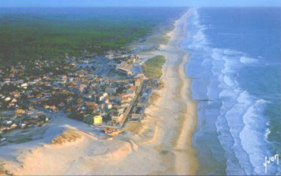
PHOTO OF THE SITE
 |
|
CASE STUDY
| Title | Aquitaine Coast |
| National level | France |
| Regional level | Aquitaine |
| Local level | from Lacanau to Cap Ferret |
ABSTRACT
|
The Region of Aquitaine is located in South-West of France, with the longest sandy coast in Europe (230km). It remains very natural with a complete shore system composed of beach, dune and pine tree forest, the most important in West Europe. Aquitaine coast undergoes a chronic erosion with more than 10m/yr in some places. Cap-Ferret is located is the south end of the sand spit of the Arcachon Lagoon, around 60km from Bordeaux. The oceanic beach is natural with no construction and the town is situated behind the dune. Northward, Lacanau is located 50km away from Bordeaux, and the coast is 5km long. A sea front is built on the dune. For both towns, the population is evaluated to 12,000 people in winter and 156,000 in summer, characterising a strong pressure from tourism. The coast is a public domain (no private beach) and the main administrator is the state. State organisms are in charge of the management of the coast (beach and dune systems). The “Office National des Forêts” (ONF) carries out the management of all the coastal public sectors. But the municipalities are in charge of the protection against erosion on the urbanised beaches and dunes. The French coast is very protected by government laws. As all the beaches are in the public domain, it is not allowed to build any construction in these natural spaces neither in the neighbouring areas. This policy must also be applied within a 100m - wide band along the coast. The main economic activity is the tourism. Important conflicts exist because of the pressure of urbanisation on the natural spaces. In order to deal with these important environmental and socio-economic aspects, the Regional Council of Aquitaine, the BRGM and the ONF are in the process of creating a coastal observatory with the scientific help of IFREMER (National Research Marine Institute). This observatory aims at providing information about erosion, protection works, sedimentary and oceanographic processes. The final objective is to provide a scientific tool for the management of the Aquitaine coastal zone. |
BASIC INFORMATION
| Coastal characteristics |
|
| Policy options | Hold the line/Limited intervention |
| Socio-economic activities | Tourism, forest, fisheries) |
| Engineering techniques | In
Lacanau: Seawall, groynes, beach nourishment In Cap Ferret: Beach nourishment, maintenance of the dune system |
SOURCE
| Name | Jean
Christophe LE BRETON Anne GUCHAN |
| Institution | Conseil Regional d’Aquitaine |
| Address | 14
Rue François de Sourdis 33077 BORDEAUX Cedex |
| Telephone / fax | +33 055 757 83 06/ +33 055 656 38 06 |
| jean-christophe.Lebreton@aquitaine.fr anne.guchan@aquitaine.fr |