| Data
description |
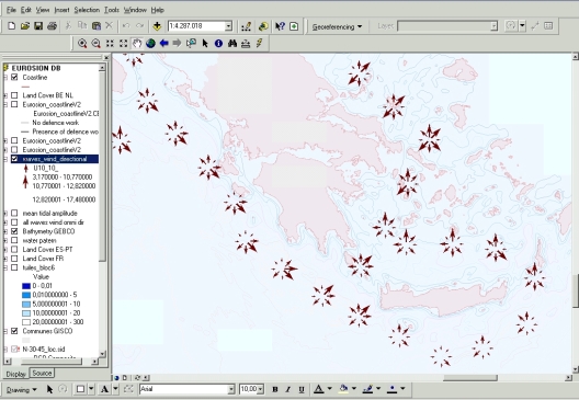
This
layer provides information on wave and wind climate at 237 locations along
the European coastline. These locations are situated 50 to 100 km away
from the shoreline. Distance from one location to another location is
approximately 100 km.
For each location, the data included in the layer provide the following
parameters:
- average
wind speed
- wind
speed exceeded by 10% of the measurements
- wind
speed exceeded by 1% of the measurements
- average
wave height
- wave
height exceeded by 10% of the measurements
- wave
heights exceeded by 1% of the measurements
- average
wave period
- wave
period exceeded by 10% of the measurements
- wave
period exceeded by 1% of the measurements
These parameters
are provided for the following directional sectors: 0, 45, 90, 135, 180,
225, 270, and 315 degrees. |
| Source
of data |
Data
were entirely generated from the EUROSION project. The parameters listed
above were statistically processed from the database waveclimate.com distributed
by the dutch company ARGOSS. waveclimate.com database contains up to 17
years of wind- and wave data (1985-2001). Observations of wave height
and wind speed come from altimeters carried by ERS-1, ERS-2, Topex/Poseidon
and Geosat satellites. The scatterometer sensors onboard ERS-1 and ERS-2
supplied the wind speed and wind direction data. Wave spectral parameters
were derived from spectra of Synthetic Aperture Radar (SAR) imagettes
collected by ERS-1 and ERS-2 using an algorithm developed by ARGOSS [Mastenbroek
and de Valk, 2000]. Production of statistical estimate for the parameters
listed above were carried out over « boxes » of 200kmx200km.
Each box overlaps with the adjacent boxes with an approximative 50% rate,
and results are attached to the box centre (see screenshot above). As
a consequence, data are provided with a 100km resolution along the European
coast. |