11. TIDAL REGIME

Tidal regime informs about the potential influence of the tides on the evolution of the European coastline. In this example, we can easily distinguish macro-tidal areas (in red), meso-tidal areas (brown or greenish), and micro-tidal areas (in green).


Data description

This layer provides information on the mean tidal range at 237 locations along the European coastline. These locations are situated 50 to 100 km away from the shoreline. Distance from one location to another location is approximately 100 km (see also layer “wind and wave climate”)

Source of data

Data 
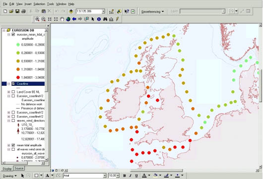
on tidal range at the 237 locations are extrapolated from the database “tidal-info. com” distributed by ARGOSS. This database contains tidal harmonics for the eight most important components, i.e. M2, S2, N2, K2, K1, O1, P1 and Q1. The harmonics were computed by assimilating eight years of radar altimeter orbit height measurements and tide gauge measurements from approximately 7300 coastal stations into a shallow-water tidal model. The satellite measurements give a good overview of the tidal patterns on deep water, whereas the stations give accurate information for certain locations close to the shoreline. The combination of the two, assimilated in a tidal model, provides good information in shallow coastal seas where tidal effects are most prominent.

Geographical
restrictions

No data have been computed for the ultraperipheral regions and for Cyprus.

Quality Source data have been severely checked and corrected. Double control on the quality of the produced database is currently ensured. The overall accuracy of tidal range estimates lies between 10 and 15%.
Copyright and data access conditions Though ARGOSS database is copyrighted, the extrapolated data on tidal range derived from EUROSION are copyright-free and are therefore publicly available inside and outside the European Commission.