6. GEOMORPHOLOGY AND GEOLOGY

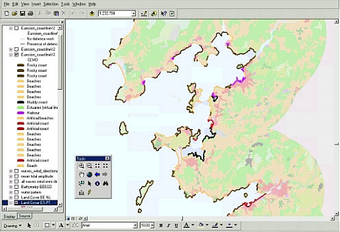
Morpho-sedimentology along the coast of Galicia, near Vigo and Pontevedra (Spain). The coastline is divided into contiguous segments, each of them representing a homogenous geo-morphological type. 20 different geo-morphological types have been defined. However, they may be aggregated into 6 major types (rocky coasts, beaches, muddy coasts, estuaries, harbours, and artificial coasts). This screenshot illustrates a complex coastline along which all geo-morphological types are present.


Data description

The layer features both morpho-sedimentological and geological patterns of the European coastline at scale 1:100,000 and in vector format. The data consist in a segmentation of the EUROSION shoreline. Both a geomorphological and a geological code is assigned to each segment. 20 different geomorphological types (and thus codes) and 13 geological types have been defined.

Source of data

The layer mainly results from an update of CORINE Coastal Erosion version 1.0 (CCEr v1.0). CCEr v1.0 was carried out by the European Commission from 1985 to 1990. This version covers European Union countries as of 1990. The update of CCEr version 1.0 and the extension of the database to countries which joined EU after 1990 and to accession countries was part of EUROSION assignments. These new or updated data are mainly derived from ancillary data such as national geological maps, reports, or existing database (such as FutureCoast for England and Wales).

Geographical
restrictions

Most of European countries are fully covered. Restrictions concern Romania, Bulgaria, Cyprus, and ultra-peripheral regions which coastline is only covered 20%.

Quality Source data have been severely checked and corrected. Double control on the quality of the produced database is currently ensured.
Copyright and data access conditions As a EUROSION assignment, this layer is publicly available inside and outside the European Commission.