| Data
description |
This
layer contains information on the location and characteristics of areas
with a high ecological value. Because of restrictions in accessing the
most updated and accurate information on areas of high ecological areas
(provided by Member States in the framework of the Habitats Directive),
the following approach has been adopted by EUROSION:
- in a
first stage, data on areas of high ecological value will be derived
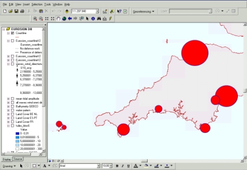
from CORINE Biotopes. The data depict the location of major nature sites
in Europe (NB: only coordinates of centroids are provided, not the geographical
boundaries of the sites). The characteristics of these sites in terms
of size, number of species hosted by the sites, or legal status are
provided as attributes of the centroids. This makes it possible cartographic
representation in the forms of bubbles (see screenshots).
- in a
second stage, the above mentioned Biotopes database will be progressively
replaced by the database of proposed Sites of Community Interest (pSCI)
- which is being established in the framework of the Habitats Directive
and Natura 2000 network – as data become public. For the time being,
only pSCIs for the Macaronesian ecoregion (Canary, Azores, Madeira)
are publicly available, which makes impossible any exploitation of these
data for European-wide applications.
|
| Source
of data |
CORINE
Biotopes is a relational database made of different tables including:
(i) species tables (mammals, birds, reptiles, etc.), (ii) habitats tables,
(iii) natural sites tables, and (iv) look up files. Since CORINE Biotopes
data are not referenced in a GIS format, geocoding operations of the whole
database are being carried by EUROSION.
As for Natura
2000 GIS files, they are still in the process of validation and are therefore
not accessible for EUROSION. |
| Geographical
restrictions |
CORINE
Biotopes is being extended under the lead of the European Environment
Agencies (EEA) for accession countries. However, these data will not be
available before the completion of EUROSION. |
| Quality |
Quality
of CORINE Biotopes is considered as sufficient to carry out the coastal
erosion assessment. However, the database itself suffers from various semantical
and structural inconsistencies, which should be partly fixed by the ongoing
Natura 2000 enhancement project. |
| Copyright
and data access conditions |
CORINE Biotopes data (non relevant for GIS purposes) are downloadable for
free from the web site of the European Environment Agency (EEA). However,
the same data - geocoded to fit GIS applications - will be made publicly
available through the EUROSION database, without restrictions. |